
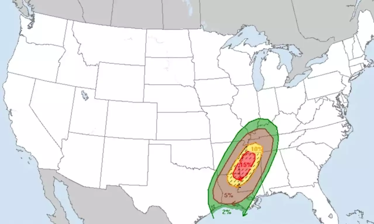
It's rare that federal forecasters warn of major tornadoes with the potential for carving damages across long distances, but they are doing so in Tuesday's forecasts.
"Multiple rounds of severe thunderstorms -- some capable of long-tracked tornadoes with EF3+ damage potential -- will be possible this afternoon into tonight over parts of the lower Mississippi Valley region and Mid-South," the Norman, Oklahoma-based Storm Prediction Center said.
Tornadoes with an EF3 rating on the Enhanced Fujita tornado scale can produce wind gusts of up to 165 mph. Flood watches were issued Tuesday for parts of southeast Mississippi and southwest Alabama, where 3 to 5 inches of rain could lead to flash flooding, the National Weather Service said. The Mississippi Emergency Management Agency urged residents to have multiple ways of receiving weather alerts and know in advance where to go to stay safe. The agency also urged people to take pictures of their homes before severe weather strikes.
"These photos can be used for insurance purposes and/or possible assistance if your home is damaged in the storm," the agency said on Twitter.© 2022 The Associated Press. All Rights Reserved. This material may not be published, broadcast, rewritten, or redistributed.Please enter email address to continue
Indonesia Berita Terbaru, Indonesia Berita utama
Similar News:Anda juga dapat membaca berita serupa dengan ini yang kami kumpulkan dari sumber berita lain.
 Sunshine Monday, Storms Late Tuesday Into Wednesday - Alabama NewsSunday night turns cooler, with lows in the 40s while the sky remains generally clear. Sunshine remains abundant Monday, with afternoon highs in the mid to upper 60s. Monday night lows cool into the 40s, but Tuesday looks warmer with highs in the low to mid 70s.
Baca lebih lajut »
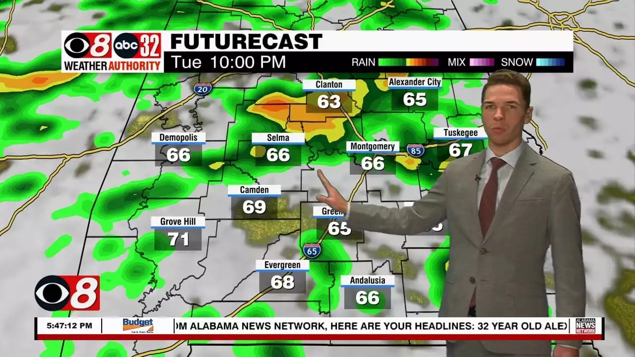
 Sunshine Monday, Storms Late Tuesday Into Wednesday - Alabama NewsTuesday looks warmer, with clouds increasing during the day. High temperatures range from the low to mid 70s. Rain and storms appear possible in central and south Alabama during the afternoon. However, rain and storm coverage increases during the evening through Tuesday night.
Baca lebih lajut »
 Strong To Severe Storms Likely Tuesday Into Wednesday! - Alabama NewsWe’re in the midst of the fall severe storm season and it’s looking like tomorrow afternoon into Wednesday will be rather active with storms! The main threats will be a few tornadoes, damaging winds up to 60mph, and quarter size hail. A few storms enter west Alabama around 4pm Tuesday and advance eastward. These storms could be strong maybe severe...
Baca lebih lajut »
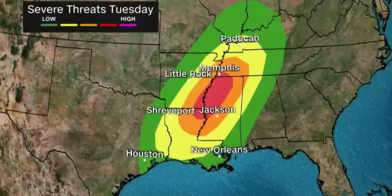 Storms could spawn major tornadoes, floods in several statesMore than 25 million people will be at risk as Tuesday’s potent storm system moves across a region stretching from east Texas to Indiana and Georgia.
Baca lebih lajut »
 Storms could spawn major tornadoes, floods in several states, including TexasForecasters are warning of severe weather across much of the United States. severeweather severewx texaswx kprc2 click2houston us weather
Baca lebih lajut »
 Forecasters Warn of Tornado Threat Across the SouthA potent storm system will drop heavy snow across the Central Plains and into the Midwest, all while delivering severe storms that will be capable of producing significant tornadoes in the South on Tuesday. A regional tornado outbreak is possible Tuesday afternoon and evening across parts of the lower and mid-Mississippi Valley, forecasters at the Storm Prediction Center wrote Monday. “These could be long-lived and intense storms,” National Weather Service forecasters in Memphis, Tennessee, wrot
Baca lebih lajut »