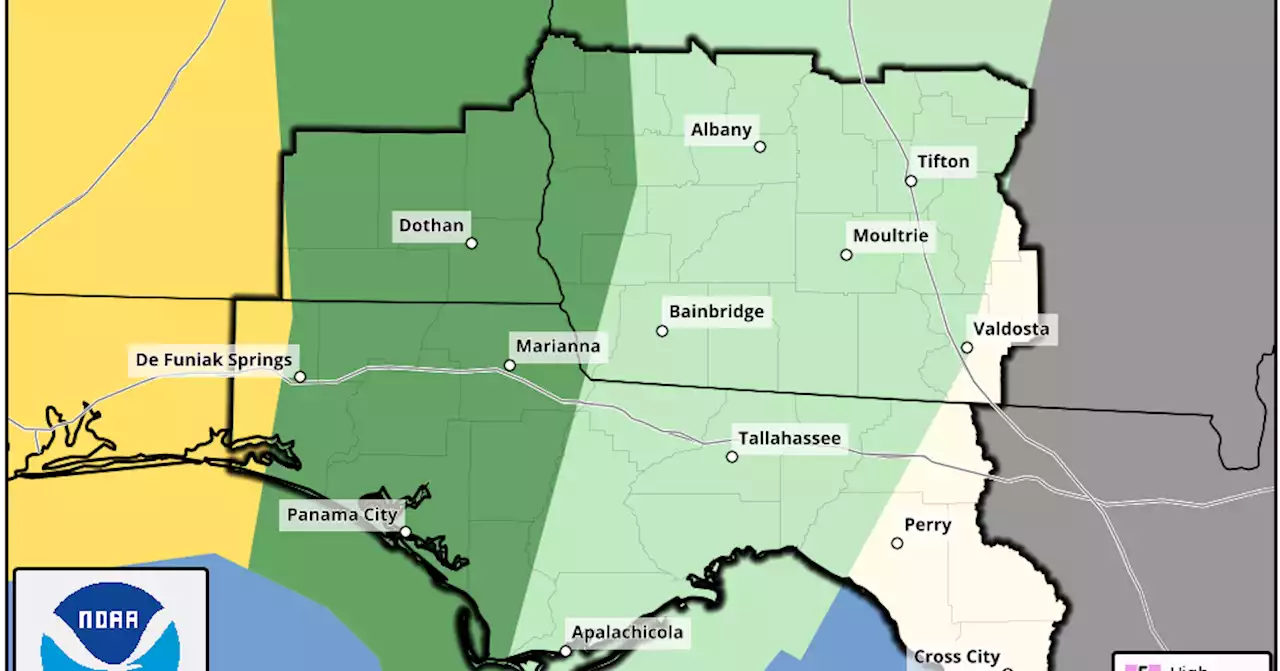
The Wiregrass could see another round of thunderstorms starting late Tuesday night – just days after a deluge swamped local streets and dropped 3 to 6 inches of rain.
An approaching strong cold front could usher in severe weather Tuesday night with the greatest threat window near daybreak on Wednesday, according to the National Weather Service in Tallahassee. Isolated storms could develop Tuesday afternoon and evening prior to the main squall line’s arrival.
“We’re really expecting marginal to slight risk here in Houston County over the next 48 hours or so,” Dothan-Houston County Emergency Management Director Chris Judah said Monday.People are also reading… Rain-wise, the system is not expected to cause the flash flooding concerns associated with Friday’s rainfall, Judah said. However, there is a lot of wet vegetation out there, so high wind gusts could take down trees, he said.
“Springtime is coming; this type of weather is going to pop up here and there,” Judah said. “We want people to take this time to plan, go ahead and take a preemptive strike and make sure that all their stuff is ready.” Houston County’s Assistant County Engineer Tyler Reeder said county crews have addressed most of problems created by Friday’s heavy rains, which led to washouts on dirt roads as well as some damage to road shoulders. As of Monday, most dirt roads had been repaired with crews still working on Hicks Road and Pate Road in Wicksburg still closed.
Indonesia Berita Terbaru, Indonesia Berita utama
Similar News:Anda juga dapat membaca berita serupa dengan ini yang kami kumpulkan dari sumber berita lain.
 Severe showers, thunderstorms expected Monday in San AntonioThe National Weather Service predicts morning rain before strong to severe storms move...
Baca lebih lajut »
 NWS: EF-1 tornado touched down in Washington County, Indiana FridayUPDATE: The National Weather Service has confirmed an EF-1 tornado touched down in Washington County Friday evening. kylemounce will have your latest forecast tonight.
Baca lebih lajut »
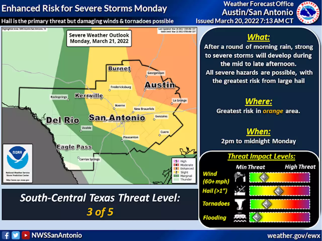
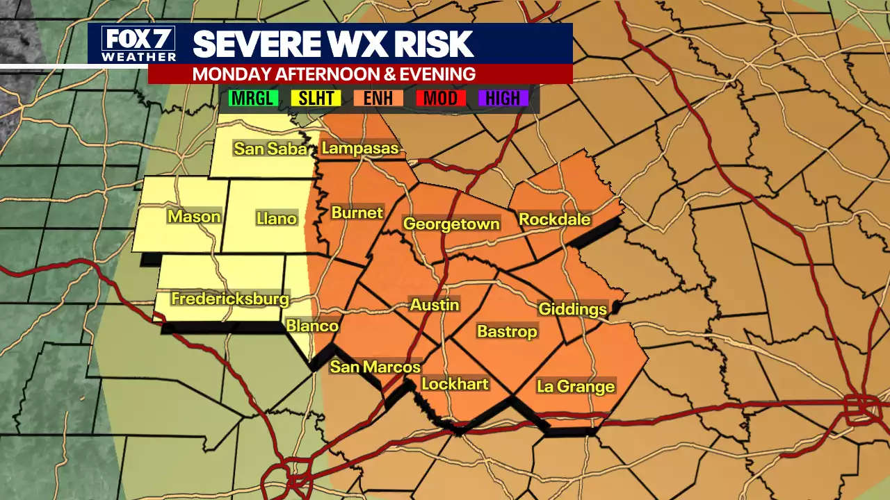 Enhanced Risk for severe weather issued for Central Texas area for Monday, March 20Severe weather is in the forecast for Central Texas on Monday, March 20. Thunderstorms, tornadoes, hail and gusty winds are all possible.
Baca lebih lajut »
 What you should do if your power is out during severe weatherAs the expected severe weather moves across the Houston-area into Tuesday, the first item most residents will be the most concerned about is power and gas lines.
Baca lebih lajut »
 Red flag fire warning today in Hill Country, Edwards Plateau, Rio GrandeThe National Weather Service upgraded that risk as well as the likelihood of severe...
Baca lebih lajut »
 Tips to protect your car from hail damageSevere weather is already back for the springtime. This means possible hail damage amidst strong rain and thunderstorms. In fact, hail could be in the mix as strong storms move into parts of Texas on Monday.
Baca lebih lajut »