
For a preview of what the Bay Area can expect in the coming days, The Examiner on Wednesday spoke with MurdockWx.
A frigid weather system is forecast to slam the Bay Area this week, bringing high velocity winds, rain showers and, yes, even, packs of snow to some of the region’s highest peaks.
So snow in San Francisco this week is not going to be a strong possibility. There might be a few flakes that fall around the town itself, but it’s going to be hard to do. It’s when you finally get into the higher elevations. So looking from San Francisco, Mount Tamalpais is looking like a good place for a dusting, as well as some of the East Bay hills and then in the Santa Cruz Mountains. But as far as seeing that getting down to sea level, it’s going to be pretty hard.
Like you said, it is going to be pulling in colder air. Tonight is going to be one of the colder nights. We’re looking at interior North Bay, so think of the valleys and Sonoma County, that’s when we’re going to be seeing around 30 degree temperatures. Santa Rosa could get down to 28. Off towards southern Santa Clara County, we’re starting to see below 30 degrees as well. And then in interior Monterey County, there could be a few areas getting down all the way to the mid-20s.
So we’ll stay on the breezy side for this afternoon, but yeah, definitely an improvement compared to what we saw yesterday . As we go into late night Thursday to early morning Friday, we’ll start to see that wind line up pretty well again. Thursday night in San Francisco Bay proper is probably going to be the windiest in that area, but then it moves farther to the south.
if you're looking for snow, but it's snow advisory criteria, people will sometimes call it weather tourism. A lot of high-impact weather can be interesting, but unfortunately if you put yourself out into those conditions you’re not just putting yourself at risk, you’re putting the people that have to recover you at risk if something goes wrong. If you don’t have the setup to handle winter weather, don’t go looking for it.
Indonesia Berita Terbaru, Indonesia Berita utama
Similar News:Anda juga dapat membaca berita serupa dengan ini yang kami kumpulkan dari sumber berita lain.
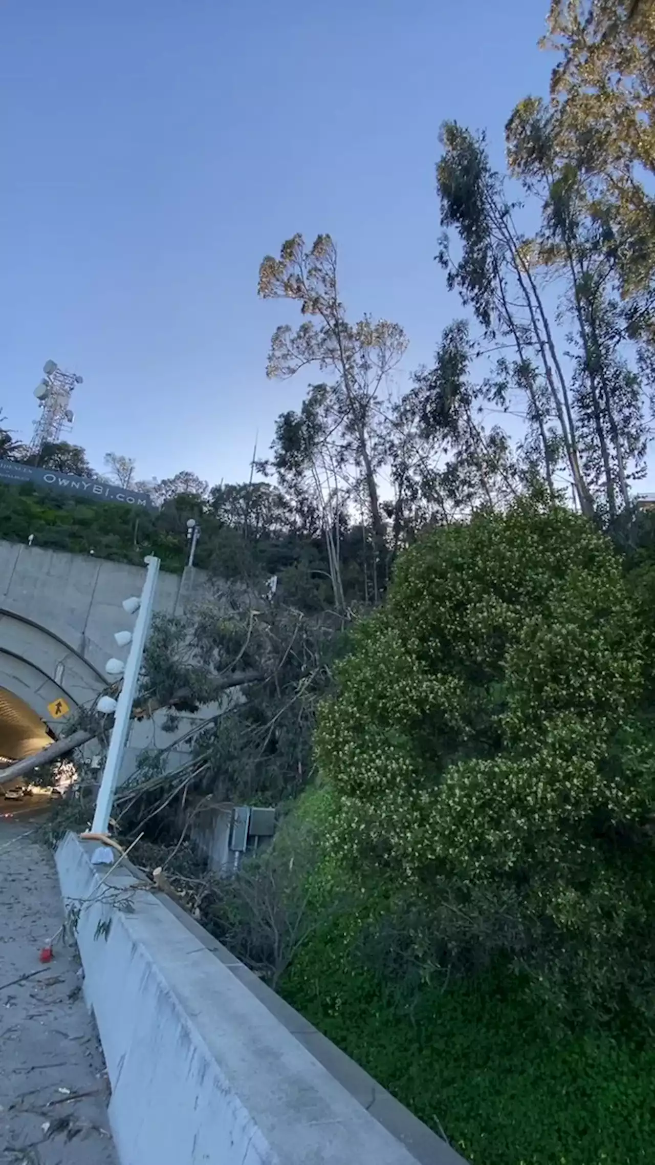 Bay Area weather updates: Large tree blocking several westbound lanes on Bay BridgeCrews are quickly working to clean up a large tree that fell and blocked several westbound lanes on the Bay Bridge causing a massive backup Tuesday afternoon. As of 5 p.m., the CHP says the 1-4 lanes are open but the 5 lane is still closed.
Baca lebih lajut »
 Bay Area weather updates: Some WB lanes of Bay Bridge reopen after downed tree causes backupThe third and fourth lanes of the Bay Bridge have reopened as of 4:52 p.m. after crews cleared out the downed tree, the CHP said. The fifth lane will remain closed for at least two more hours.
Baca lebih lajut »
 High winds topple tree on Bay Bridge as PG&E prepares for next Bay Area stormThe upcoming Bay Area storm could see snow at lower elevations than usual, and high winds expected to cause thousands of power outages throughout the region.
Baca lebih lajut »
 Icy, Snowy Mess Expected for NYC Area Today; NWS Surveys Possible NJ Tornado SiteNational Weather Service experts are expected to canvass a New Jersey community later Wednesday for signs a confirmed tornado hit during Tuesday’s line of severe weather — while more precipitation is already in the forecast. If the Lawrence Township incident is confirmed to be a twister, it will be quite a weather rarity, though not unprecedented. It would be one…
Baca lebih lajut »
 NWS: Accumulating snow most likely Wednesday during morning, evening commuteLight snowfall is falling across the Denver metro area Wednesday morning, meaning roads will likely stay snow-covered and icy for both the morning and evening commute.
Baca lebih lajut »
 NWS confirms tornado hit Mercer County, New Jersey; witness says it was 'like Wizard of Oz'The National Weather Service has confirmed a tornado touched down in Mercer County on Tuesday afternoon.
Baca lebih lajut »