
This summer, NOAA & citizen scientists will map the hottest parts of 18 communities across the U.S. & in 1 international city. Learn how this project will reduce the health impacts of extreme heat: HeatGov NOAAClimate ClimateReadyNation CitSci
— areas with few trees and more pavement that absorbs heat — can be up to 20 degrees fahrenheit hotter than nearby neighborhoods with more trees, grass and less black asphalt.
“The burden of heat is not shared equally in our urban areas,” said NOAA Administrator Rick Spinrad. “Gathering this type of environmental intelligence helps communities measure their hottest places so they can develop strategies to reduce the dangerous effects of heat. Community by community, we’re working to create a Climate-Ready Nation that is resilient in a changing world.”
NOAA will work with citizen scientists to map urban heat islands in multiple cities and counties in 14 states this summer and in one international city, Santiago, Chile. Since 2017, NOAA and its science partner, CAPA Strategies, have worked with more than 70 communities to create heat island maps that can be used to inform cooling strategies.
Indonesia Berita Terbaru, Indonesia Berita utama
Similar News:Anda juga dapat membaca berita serupa dengan ini yang kami kumpulkan dari sumber berita lain.
 Sutter Health Asks for Help Identifying Patient Hit by Car in San LeandroSutter Health is asking for the public’s help in identifying a patient brought to the hospital after being hit by a car near the San Leandro BART station on March 16.
Baca lebih lajut »
 Black Republican receives applause for identifying as 'American' during heated debate on DEI initiativesMissouri State Rep. Justin Hicks (R) joined 'Fox & Friends First' after he fended off questions on his ethnicity from a Democrat on the State House floor.
Baca lebih lajut »
 NOAA: Ian was Cat 5 before weakening at Florida landfallHurricane Ian briefly reached maximum Category 5 status before weakening to a Category 4 storm as it blasted ashore last September in southwest Florida, eventually causing over $112 billion in damage in the U.S. and more than 150 deaths directly or indirectly
Baca lebih lajut »
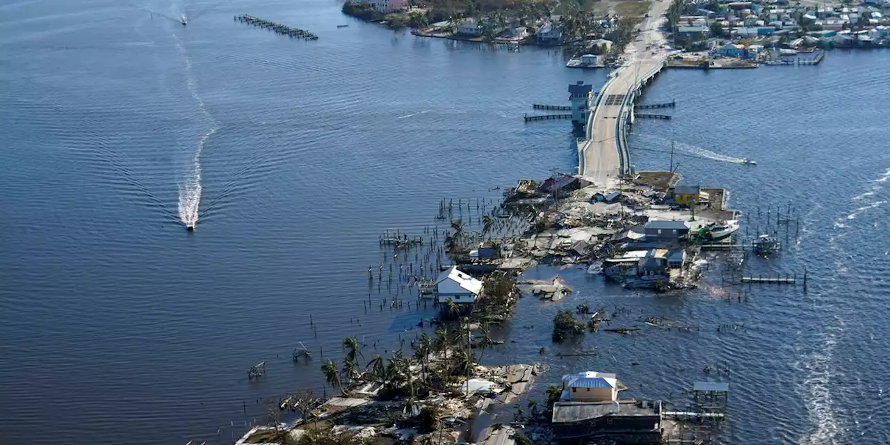
 NOAA: Ian was Cat 5 before weakening at Florida landfallHurricane Ian briefly reached maximum Category 5 status before weakening to a Category 4 storm as it blasted ashore last September in southwest Florida, eventually causing over $112 billion in damage in the U.S. and more than 150 deaths directly or indirectly.
Baca lebih lajut »
 NOAA: Ian was Cat 5 before weakening at Florida landfallHurricane Ian briefly reached maximum Category 5 status before weakening to a Category 4 storm as it blasted ashore last September in southwest Florida, eventually causing over $112 billion in damage in the U.S. and more than 150 deaths directly or ind...
Baca lebih lajut »
 NOAA: Hurricane Ian was Category 5 before weakening at Florida landfallThe NOAA report also says Ian was the costliest hurricane in Florida history and the third-costliest ever in the U.S.
Baca lebih lajut »