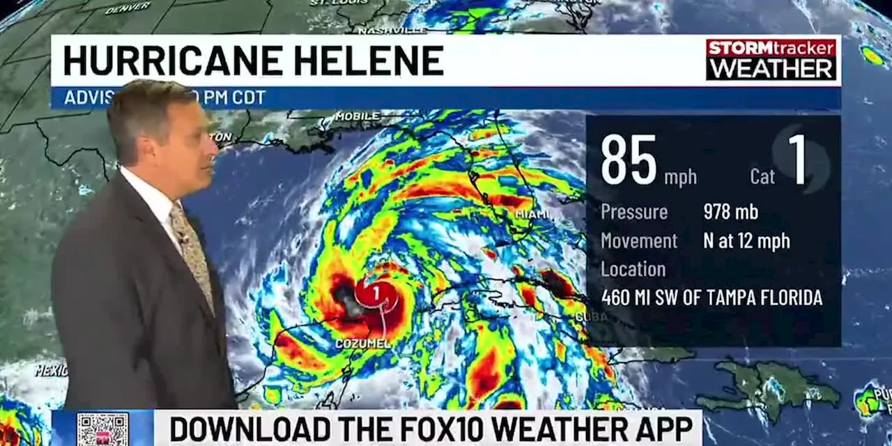
Hurricane Helene continues to strengthen as is moves across the southeastern Gulf of Mexico.
) - Winds are now at 85 mph sustained, with significant strengthening possible. The National Hurricane Center is predicting the storm to reach Category Four strength prior to landfall. This is an unusually large hurricane in size. Significant winds will be expected near and well east of the center.
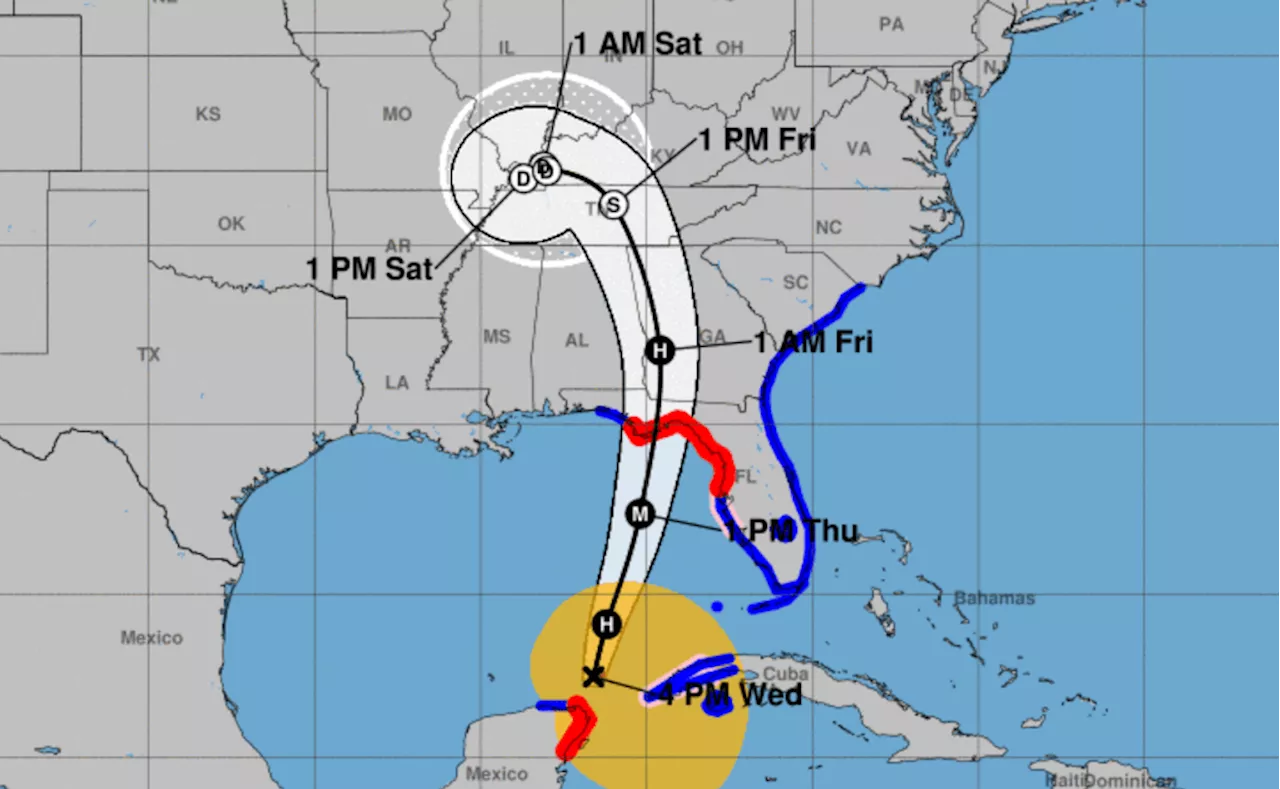
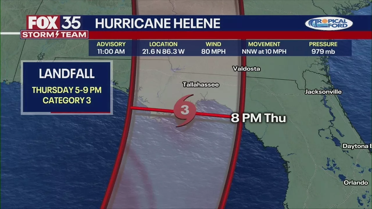
The hurricane is moving north at 12mph. A turn to the north-northeast is expected tonight and Thursday. An upper trough should keep Helene from directly affecting our area. Landfall is likely in the Florida Big Bend Region tomorrow evening. The core of the storm will pass over the warmest water in the Gulf. The high oceanic heat content will fuel intensification. The upper air environment and the absence of upper level wind shear will also support strengthening.
Locally, we expect rough surf and dangerous rip currents at our beaches. Rain chances are highest along the western Panhandle, especially in Santa Rosa and Oklaloosa Counties. We could see tropical storm conditions in those locations. Tides may be 1-2 feet above normal. Overall, our impacts will be minor in comparison to our neighbors to the east.Copyright 2024 WALA. All rights reserved.
Tropics Hurricane Gulf Of Mexico Florida Alabama Storm Radar Track Models Forecast
Indonesia Berita Terbaru, Indonesia Berita utama
Similar News:Anda juga dapat membaca berita serupa dengan ini yang kami kumpulkan dari sumber berita lain.
 Hurricane Helene may make landfall in Florida as Category 4 storm; residents flee Gulf coastForecasters said Hurricane Helene will intensify rapidly over the next 24 hours and grow huge as it approaches landfall on Florida’s Panhandle. Residents began to flee ahead of the storm.
Baca lebih lajut »
 Live updates: Helene now a Category 1 hurricane; likely a major hurricane at Florida landfallHelene strengthened into a hurricane on Wednesday and is expected to strengthen further – potentially becoming a major hurricane – before making landfall over Florida on Thursday. Life-threatening storm surge, damaging winds, torrential rain, and flooding are possible.
Baca lebih lajut »
 Hurricane Helene Strengthens To Category 1, Expected To Become Major Hurricane Before Florida LandfallHurricane Helene intensified into a Category 1 storm Wednesday and is projected to strengthen further, potentially reaching major hurricane status (Category 3 or higher) before making landfall in Florida Thursday. The storm threatens life-threatening storm surge, damaging winds, torrential rain, and flooding across parts of the Sunshine State.
Baca lebih lajut »
 Hurricane Helene live updates: Storm upgraded to Category 1 as it takes aim at FloridaWatch a live tracker of Hurricane Helene as it heads toward Florida and is expected to make landfall Thursday evening.
Baca lebih lajut »
 Helene forecast to strike Florida as a Category 3 hurricaneModel data has been consistent and in agreement, but any shift in position over the next 24 hours could make a huge difference in landfall location.
Baca lebih lajut »
 Storm expected to strengthen to Category 3 Hurricane Helene before hitting Florida PanhandleA beautiful day locally, but the Gulf is heating up, and we've got a storm on the horizon.
Baca lebih lajut »